 delhi metro
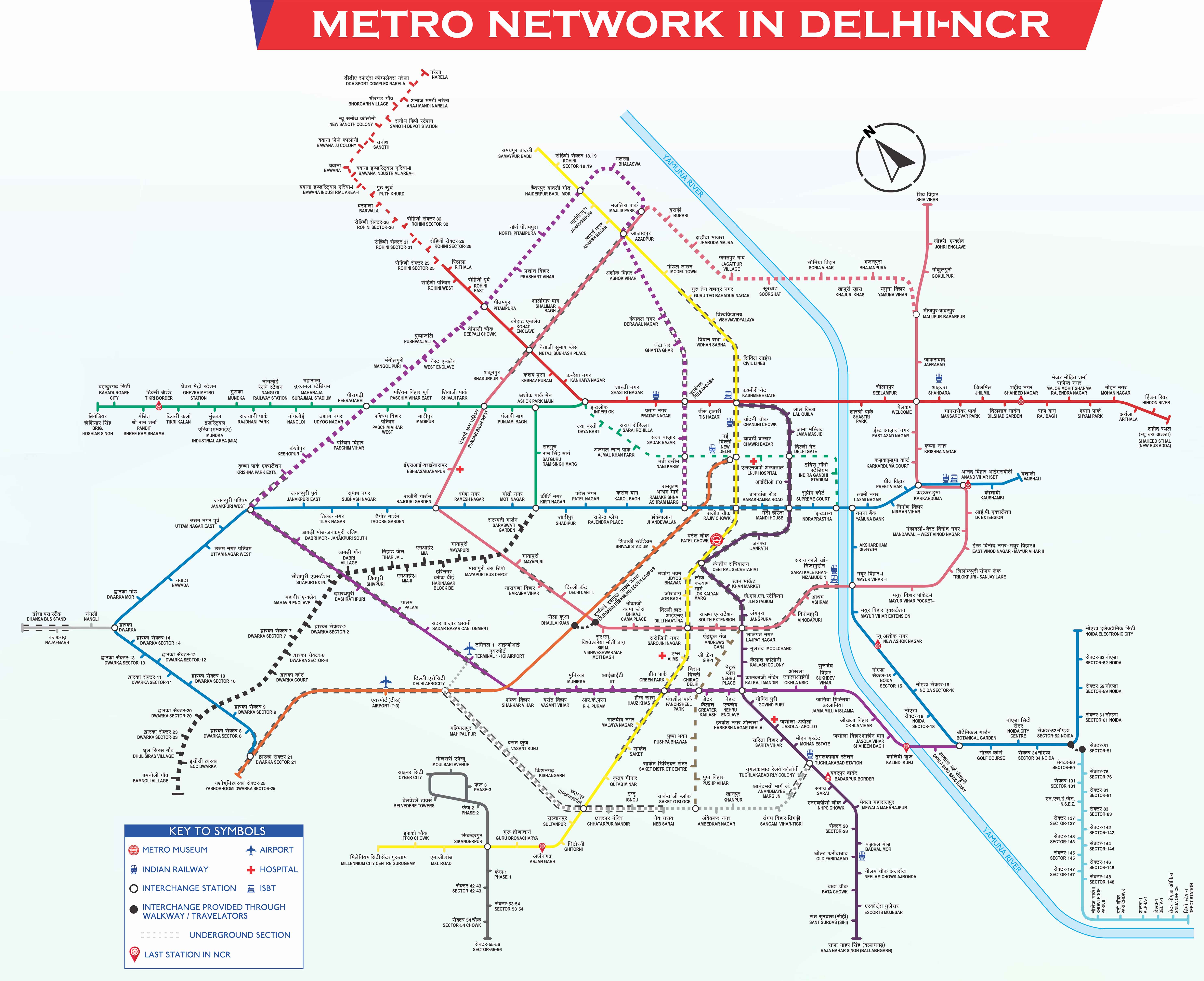
Ramakrishna Ashram Marg to Nangloi Railway Station Metro Route
Towards → Dwarka Sector 21
Platform 2
- Ramakrishna Ashram Marg
- Jhandewalan
- Karol Bagh
- Rajendra Place
- Patel Nagar
- Shadipur
- Kirti Nagar
Change here and move towards → Brigadier Hoshiyar Singh
Greenbranch Line
Platform 3
- Kirti Nagar
- Satguru Ram Singh Marg
- Ashok Park Main
Change here and move towards → Brigadier Hoshiyar Singh
Green Line
Platform 1
- Ashok Park Main
- Punjabi Bagh
- Shivaji Park
- Madipur
- Paschim Vihar East
- Paschim Vihar West
- Peeragarhi
- Udyog Nagar
- Maharaja Surajmal Stadium
- Nangloi
- Nangloi Railway Station
Ramakrishna Ashram Marg to Nangloi Railway Station Time, Fare & Details
Metro Safety Tips
- Watch out for pickpockets.
- Avoid mobile use while boarding/deboarding.
- Don’t use mobiles at coach gates.
- Never force coach gates open.
- Stay cautious with strangers.
Ramakrishna Ashram Marg Metro Station Information
Ramakrishna Ashram Marg Metro Station Entry Gates & Platform
More Metro Routes from Ramakrishna Ashram Marg Metro Station
Nangloi Railway Station Metro Station Information
Nangloi Railway Station Metro Station Entry Gates & Platform
More Metro Routes from Nangloi Railway Station Metro Station
Ramakrishna Ashram Marg to Nangloi Railway Station Metro Route Summary
The metro journey from Ramakrishna Ashram Marg to Nangloi Railway Station offers a seamless travel experience, spanning a distance of 15.82 kilometers. This route features 19 intermediate active stations, ensuring connectivity to key locations along the way. The approximate travel time between these two stations is 57 minutes, 40 seconds, making it an efficient option for daily commuters and occasional travelers alike.
The fare for this route is ₹43 as per DMRC rates, with additional discounts available for smart card users, making it an economical choice. The metro service begins early, with the first train departing from Akshardham at 5:38 AM and the last train leaving at 11:59 PM. This schedule ensures flexibility for both early morning travelers and those returning late at night.
For added convenience, this route includes 2 interchange stations, allowing passengers to switch metro lines and reach their destinations efficiently. Whether traveling for work, education, or leisure, this route offers a reliable and comfortable transit experience.
Ramakrishna Ashram Marg Metro Station is Divyang-friendly, offering accessible facilities such as Sulabh toilets, and ATM facilities. The station also provides paid parking with varying pricing slabs for different vehicle types, ensuring convenience for all passengers.
Nangloi Railway Station Metro Station is Divyang-friendly, offering accessible facilities such as Sulabh toilets, feeder bus services, and facilities.
Ramakrishna Ashram Marg Metro Station to Nangloi Railway Station Metro Station Route FAQs
The first train from Ramakrishna Ashram Marg station is at 5:38 AM, and the last train departs at 11:22 PM.
